Camino de San Salvador
125km pilgrimage route in Spain
Distance
125km
Duration
5 days
Difficulty
hard
Certification
Salvadorana
Start → End
León → Oviedo
Planning Snapshot
Distance
125km
Typical duration
5 days
Average day
25km/day
Difficulty
hard
Best months
April–June, September–October
Lodging density
low
Resupply
hard
Access
Bus to León from Madrid or Oviedo, then local transport to start. Fly into León (LEN) or Asturias (OVD).
Is this route a good fit?
Best for
Full challenge & authenticity
Time commitment
5 walking days at about 25km/day
Lodging and resupply
low lodging · hard resupply
Why use Sacred Trails
Offline stages, waypoint stories, lodging notes, and route context stay available when mobile signal drops.
Rough Distance Planner
Use this as a rough distance sketch before detailed planning: 5 walking days across 125km, averaging about 25km per day. Adjust for real stages, terrain, rest days, weather, opening seasons, and lodging availability before booking.
Total days
5
Average walking day
25km
Route style
low lodging · hard resupply
1
Walk
León → La Robla
León · 8 listed stays
25km
25km
2
Walk
La Robla → Poladura de la Tercia
Buiza · 1 listed stays
25km
50km
3
Walk
Poladura de la Tercia → Campomanes
Pajares · 1 listed stays
25km
75km
4
Walk
Campomanes → Ujo
Pola de Lena · 2 listed stays
25km
100km
5
Walk
Ujo → Oviedo
Oviedo · 6 listed stays
25km
125km
Distances are averaged. Route markers use the nearest ordered waypoint to each rough segment; lodging references are supporting town data, not recommended overnight stops or confirmed availability.
About the Route
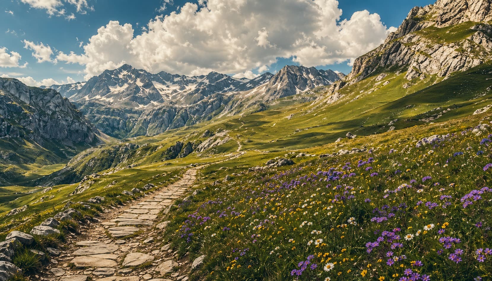
The Camino de San Salvador follows the ancient road that connected the cathedral city of León to Oviedo, where medieval pilgrims would pause to venerate one of Christendom's most sacred relics — the Holy Shroud of Christ, kept within the Cathedral of San Salvador since the early Middle Ages. A famous medieval proverb captured the journey's logic: "Quien va a Santiago y no al Salvador, visita al criado y olvida al Señor" — to visit St. James but not the Holy Saviour is to greet the servant and forget the Lord. The route climbs hard over the Cantabrian Mountains, through beech forests and alpine meadows that belong more to the rugged north than to the plains of Castile below. Short but demanding, it serves as the vital link between the Camino Francés and the ancient Camino Primitivo, binding together the two oldest pilgrimage traditions in all of Spain.
Key Waypoints
León
0km from start · 822mLeón was the ancient capital of the medieval Kingdom of León — one of the most powerful Christian kingdoms of the Reconquista. The Cathedral of Santa María de León (Pulchra Leonina) is considered one of the finest Gothic cathedrals in the world. The Camino de San Salvador begins here, heading north to Oviedo to venerate the holy relics of the Cámara Santa. Collect the Salvadorana pilgrim passport and first stamp at the cathedral or pilgrim office.
Villasinta de Torío
12km from start · 840mVillasinta de Torío preserves a 12th-century Romanesque chapel dedicated to Santiago — evidence that this ford across the Torío was a formalised stop on the medieval pilgrimage road to Oviedo from León's earliest pilgrimage era. A carved tympanum depicting Santiago Peregrino above the chapel door makes it one of the smallest yet most eloquent pilgrim monuments on the entire Camino de San Salvador.
La Candana de Curueño
34km from start · 950mLa Candana de Curueño lies in the upper Curueño valley, which served as a transhumance corridor for the Mesta sheep-rearing guild — the most powerful livestock institution in medieval Spain — whose flocks passed through each season for over four centuries. The village church of San Pelayo preserves a 12th-century dedication inscription noting its foundation under the jurisdiction of the Cathedral of Oviedo, the very destination of the Camino de San Salvador.
Buiza
41km from start · 1050mBuiza collected portazgo — a royal transit toll — from pack-animal drivers since at least the 12th century, its position on the ascent to the Puerto de Pajares making it an inescapable chokepoint. The village church of San Mamés retains a 13th-century Romanesque portal, its carved voussoirs worn smooth by centuries of mountain weather.
Puerto de Pajares
65km from start · 1364mAt 1,364m, the Puerto de Pajares is the highest point of the Camino de San Salvador and one of the most historically significant mountain passes in Spain. For centuries it was the primary land route between the Castilian meseta and Asturias. The 12th-century Colegiata de Santa María de Arbas, just below the summit, was founded as a hospice for travellers crossing this dangerous passage. Stamp at the bar/albergue in the village of Pajares.
Campomanes
77km from start · 440mCampomanes sits where the medieval road from León descended into Asturias, following the same corridor as the Roman Via Asturica Augusta. The Colegiata de Arbas monks were obliged by their 12th-century foundation charter to keep this descent passable in winter, supplying torches and guides to travellers crossing the Pajares after dark.
Figaredo
106km from start · 240mFigaredo gave its name to the Pozo Figaredo, a coal shaft sunk in 1924 by the Hullera Española company, whose headframe tower still dominates the valley skyline. The 1934 Asturian miners' uprising began just upstream in this Caudal valley; federal troops quelled it after two weeks of armed resistance.
Olloniego
115km from start · 240mOlloniego's hilltop tower was a stronghold of the Quiñones family, the powerful Lords of Luna, who used it to control traffic on the Nalón valley road in the 15th-century Asturian civil wars. The river here marked the outer boundary of the Bishop of Oviedo's direct territorial jurisdiction, beyond which the noble houses held sway.
20 waypoints total · Sacred Trails app contains full detail for every waypoint.
Points of Interest
León Cathedral (Catedral de Santa María)
· churchOne of Spain's finest Gothic cathedrals, famous for 1,800 square metres of medieval stained glass windows. The pilgrim office inside issues the Salvadorana credential. A UNESCO World Heritage Site.
Basilica of San Isidoro
· churchA magnificent Romanesque church in León housing the Panteón Real, the royal pantheon with extraordinary 12th-century frescoes. Often called the 'Sistine Chapel of the Romanesque'. Holds the relics of San Isidoro of Seville.
Church of Santa Cristina de Lena
· churchA jewel of Asturian pre-Romanesque architecture (9th century), perched on a rocky hillside near Pola de Lena. UNESCO World Heritage Site as part of the 'Monuments of Oviedo and the Kingdom of the Asturias'. A detour of 2km from the main trail.
Puerto de Pajares Pass
· viewpointAt 1,364m, this is the highest point of the Camino de San Salvador and one of the most historically significant mountain passes in Spain. The panorama from the summit stretches across both the Castilian plains to the south and the green Asturian valleys descending toward the sea to the north.
Oviedo Cathedral (Catedral de San Salvador)
· churchThe ultimate destination of the Camino de San Salvador. The Gothic cathedral houses the Cámara Santa, a UNESCO World Heritage Site, containing the most important collection of pre-Romanesque relics and treasure in Europe, including the Sudarium of Oviedo, the Cruz de los Ángeles (808 AD), and the Cruz de la Victoria (908 AD). The Salvadorana certificate is issued here.
Cámara Santa (Holy Chamber)
· museumThe sacred heart of the Oviedo Cathedral complex and the reason the Camino de San Salvador exists. This pre-Romanesque chamber (c. 802 AD) was built by King Alfonso II to house holy relics brought from Toledo fleeing the Moorish invasion. It contains the Sudarium of Oviedo, the Cruz de los Ángeles, the Cruz de la Victoria, and a 12th-century Romanesque apostle frieze of exceptional beauty.
Accommodation
Town lodging summary
24 listed staysLeón
8 stays
Rates vary; record your own price notes.
Oviedo
6 stays
Rates vary; record your own price notes.
Pola de Lena
2 stays
Rates vary; record your own price notes.
Bendueños
1 stay
Rates vary; record your own price notes.
Buiza
1 stay
Rates vary; record your own price notes.
Cabanillas
1 stay
Rates vary; record your own price notes.
La Robla
1 stay
Rates vary; record your own price notes.
Llanos de Somerón
1 stay
Rates vary; record your own price notes.
Albergue del convento de las Carbajalas
León
Rate varies
Albergue-Residencia San Francisco de Asís
León
Rate varies
Albergue Santo Tomás de Canterbury
León
Rate varies
Albergue Check in León
León
Rate varies
Albergue Muralla Leonesa
León
Rate varies
León Hostel
León
Rate varies
Zentric Hostel
León
Rate varies
Globetrotter Hostel
León
Rate varies
Camino / Gronze
Source reference
Camino accommodation entries are compiled from Gronze-oriented route research as planning references, not live inventory or an affiliated booking feed. Rates are traveler-owned notes because they change by season and operator; confirm availability directly before departure.
Showing 8 of 24 · Rates vary; use your own price notes and verify availability directly before your trip.
⚠️ Before You Go
Best avoid
November–March (mountain snow on the Puerto de Pajares crossing)
Weather risk
Snow and ice on the Cantabrian mountain crossing; route can be blocked Oct–May
Mobile signal
No signal for most of the mountain crossing
Note
One of the least-walked and most demanding short routes — physically harder than its 130 km suggest
Recommended to carry
Navigate the Camino de San Salvador Offline
Stage-by-stage navigation, waypoint history, and lodging data — all offline in Sacred Trails. Free to download with route packs for the trails you walk.